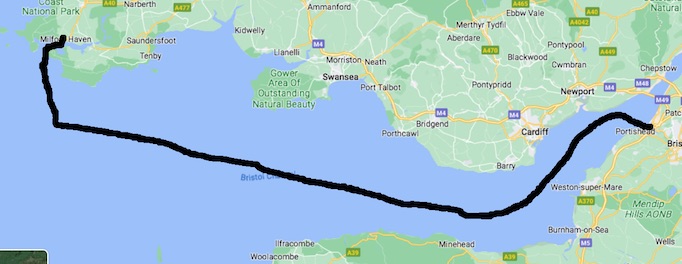
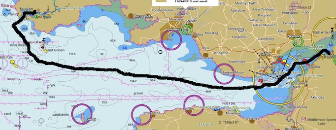
"Screengrabs" "rough-annotated" with voyage (links bring up the online maps)
| Oysterman 22 |
| rig = gaff rig |
| hull form = long-keel |
| tiller steering (not wheel) |
| length 22ft = 6.7m |
| "Froude hull-speed" : 6.7m => 6.3kt |
| Motor yes : gives about 4.5kt to 5kt on reasonable power |
| Crew for voyage : 4 in total |
| Comprising : * skipper * crew - 1 experienced * crew - 2 fairly novice |
| Minimum two in cockpit
(hence why crew 4 in total for through-night two on watch). |
| Neap tide (14April2023) |
| High tide on 15April2023 16:00 (4pm) |
| Wind - negligible on departure and most of voyage |
| Swell (waves) on open sea - yes |
| Sunny at departure
quickly turning to overcast and cold no rain - 10mins of drizzle in entire voyage fog at destination |
| Depart Portishead Sat. 15th April at 15:00 (3pm) - 1 hour before high water |
By:
| charts - set of charts for Bristol Channel to and including all of Pembrokeshire to Western tip |
| compass - seen rear-facing on cabin front wall of cockpit |
| during day - observation for familiar landmarks |
| at night - observation of lighthouses, cardinal buoys, town lights, etc |
| GPS coordinates available to read on radio when at chart-table |
No wind => motoring. Auto-helm on after reaching channel.
Departing 1 hour before high water gave little current then current increasingly in favour of the voyage, with ebb flowing West.
(high water necessary to leave Portishead marina, with extreme tidal range in the Bristol Channel and Portishead / Bristol area)
Easy conditions. Sunny. Had meal.
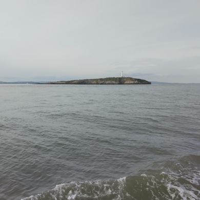
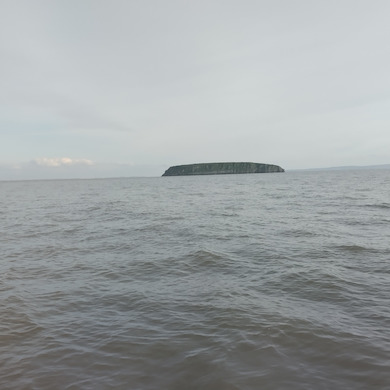
Looking to Flat Holm (N) and Steep Holm (S)
No wind => motoring. Auto-helm on.
Choppy waters out of all proportion to wind (none) and other weather (mild) as incoming ocean swell met outgoing ebb flow of tide.
Motoring direct in steep choppy waves.
No sails up = bare mast.
Consequently - pitching-and-rolling (notable negative effect of being
on a sailing vessel motoring, where a motor-boat would be optimised
for motoring).
Volunteered subsequent interjected comment from experienced seafarer as started to try to describe situation "Sod that!" (it's familiar and a notoriously undesirable situation)
Ilfracombe and Port Talbot / Swansea seen in daylight; Barnstable / Bideford area seen after dark.
Lundy light (lighthouse) seen.
No wind => motoring. Auto-helm on. Bearing set 275deg on auto-helm - compass concurring 275deg heading in main apart from one hour where compass showing 270deg heading while auto-helm remaining on the 275deg setting.
Essentially this was past Gower Peninsula and Carmarthen Bay. That Carmarthen Bay section putting yacht far out to sea.
Myself - "early session" sleeping - 20:30 (8-30pm) to bunk - slept
until nearly midnight.
During that early night time - yacht sometimes "slamming" despite
long-keel (good riding of harsh conditions). Crockery in lockers
sometimes slightly "jumping" and landing.
Wave motion vertical acceleration causing to myself notable increase
and reduction of apparent weight. Mattress crushing thin and
springing-up thick with that apparent weight effect.
Around midnight awoke and to cockpit relieving one of the three there.
Other went for sleep too.
Skipper and self kept watch until about 01:30 when skipper to bed and
other crew joining me in cockpit.
Early hours - went for another hour of sleep.
Returned to watch from cockpit paired with other crew member.
Attire for rest of voyage until inside Milford Haven was waterproof trousers over moleskin trousers; vest, shirt, thick "fleecy" pullover and lined coat; snood, two woolly hats one on top of the other, covered by hood of coat and coat fully zipped-up to form neck cover to chin; plus gloves most of the time.
Rough estimate 35deg of roll angle (70deg of included arc of roll)
ie the notable propensity of a sailing vessel with bare mast to
roll when motoring. Where motor-sailing is much preferred (reputedly,
given never myself yet experienced motor-sailing in harsh conditions).
Result of watch - all through night and all through voyage - no other vessels nearby and very rarely any in sight at all. ie no duties came to the watch (though obviously keeping a watch to be done).
Succession of cardinals seen through night - observations reconciled with chart.
Daylight arriving - probably off Castlemartin Peninsula.
Sail to off Milford Haven.
Early full daylight and skipper emerged. Motion of yacht changed and skipper sensing there is wind. Disengaged motor and and come to near-stop confirmed now enough wind to sail.
Sails - main = gaff rig; foresails = jib sail and staysail.
For myself, first time seen a gaff rig deployed. Two halyards; the throat halyard (to front of sail) and peak halyard (to end of gaff).
Yacht sailing; motor turned off.
"auto-helm" not strong enough to function when sailing, so manual helm.
Sailing - log indicates around 6kt (fast = approaching the "Froude" hull-speed)
Helmed - holding heading of 345deg.
No land in sight or other stationary marker. Hence steering solely on
compass.
Sighting the compass diagonally across the cockpit, so holding the
45deg-to-starboard mark on 30deg to the compass as seen.
Apparent wind at about 160deg from bow to port-side - so very close to
"running with the wind" ("a very broad broad-reach"). With risk of
unintended gybing if yacht bears-away further from wind.
Sea - swell estimated 2m (others concur). Seemed to me to be mainly
from direction 45deg to the bow on the port-side, ie not
matching the wind (not concurred-with). Summation of waves
(superposition, "reinforcement") producing peaks, suggesting swell /
waves from slightly mixed directions (??).
The reach almost a run combined with the swell direction made the yacht unstable regarding holding a heading, needing by-the-second strong inputs on the tiller to hold heading.
Hence nearly continuous observation of compass as sole means to hold course.
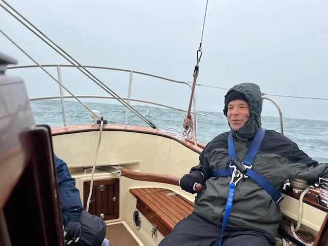
Concentrating on compass - reason for looking diagonally across the cockpit. Feet braced against edge of opposite seat and left arm hooked around capstans for control when applying large rapid forces to tiller. Note the large angle rudder input being applied given at 6kt, which is very near to the Froude hull-speed of 6.3kt (~"the maximum").
Notably - it could be to advantage to apply a correction when on the local peak of a wave superposition, rapidly giving up to around 10deg of movement which in such a short fraction-of-a-second timescale could be seen in daylight by the bowsprit moving relative to the waves in that instant and stopped by centring the tiller.
Most helm input was against the yacht heading up (turning towards the
wind) so needing starboard rudder. Which meant pulling to tiller
given conventional sitting to windward. Hence sitting normally but
with feet braced against edge of seat on opposite side of the cockpit,
in order to be able to rapidly apply the large corrections.
(my frequent method - left arm around windward capstans; right hand on
tiller - helping "react" to tiller force and enabling / steadying turn
to look over bow).
Some correction against yacht bearing-away - so push tiller.
Crab-pot spherical floats occasionally seen. None forced course-change, but concern that where there's one there may be more and some seen forming a line suggesting need to ensure that no crab-pot(s) ahead of bow, on the course. Close watch kept, particularly at those moments.
Passed Turbot Bank to our starboard clear of the West cardinal.
Passed helm to other crew member, so all but skipper had helmed.
Good, but declining wind-speed had logged speed through water reducing
to about 3kt to 3.5kt, with the sails flogging in the only slightly
reduced swell.
Had deliberately over-shot Milford Haven, so time to change to heading to enter Milford Haven came at that juncture.
Motored into and along the Haven.
Skipper "called" that would head for the West Channel into the Haven.
Conditions
| wind "disappeared" |
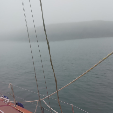
Note that with fog so no land or markers visible despite being close to land, helmsperson steering by continuous watch of compass. So not able to contribute significantly to look-out.
Skipper checking log positions against GPS at the chart-table.
St. Anne's port marker buoy came into sight on port side, about
simultaneously to West cardinal to starboard.
Soon followed the the "ghostly" in the fog Mid Channel rocks
marker estimated less that 100m away to starboard.
Skipper to cockpit, so three in cockpit (4th crew member sleeping).
Good number given
| one mainly looking at chart |
| one on the helm mainly steering watching the compass |
| one mainly on look-out |
Note fog was so thick that navigation marker buoys were most often
seen in vague form with their type only being confirmed when very
close / alongside. Declaring only bearing and estimated distance
initially.
Sometimes having to declare "suspected of being a <...>; to be
confirmed", until finally "Confirmed. Is a <...>".
Had been observing to stern about every couple of minutes and
reporting "Nothing to report to stern".
It seemed on first principles poor form if we managed to follow the
channel so far but were oblivious of until run-down by half a million
tonnes of supertanker holding a steerage-way twice our speed coming up
behind us. Subsequently the skipper commented he would have
instructed to also watch to stern, but was pleased that was
unnecessary as the need was "seen" and the task being done.
Succession of channel-markers, cardinals and glimpses of headlands fitted with expectation from chart.
North of Angle (the name) North Cardinal, turned to course 90deg to go
down the Haven. Passed Thorn Rock West cardinal to starboard then
"Chapel" starboard channel marker to starboard.
Emotional significance of this description is that visibility was so
limited that it took three in the cockpit to confidently keep up with
the observations.
Went outside main channel to the South ("starboard") side in deep water up to cliff to lower mainsail and deploy fenders.
[Believed to be about 051deg 41' 32.2" N 005deg 06' 37.2" W]
Plus "catch a breather".
Because Milford Haven was living up to its name - being a haven. Flat
as a millpond. Noting he 2m swell outside.
In very thick fog, continued motoring down main navigation channel,
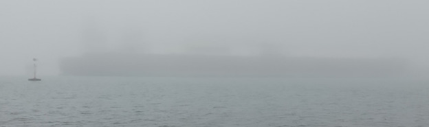
coming upon "ghostly" sightings of jetties and ships.
eg Qatary "Q-Flex" LNG carrier - bridge was invisible in low
cloud and initially which way around (bow and stern) were mistaken
despite some familiarity with the ships.
Proceeding along seeing unloading arms with connections on the jetties.
Found "preferred channel to starboard" red-green-red buoy indicating entrance to side channel North up to the Milford Haven town / dock lock.
Continued at tick-over down haven past Valero jetties on South side while calling-up marina.
Invited by into lock to tie-up at floating pontoons with caveat that bit
of time until lock gates would be closed. Tied-up. Done it...
Breakfast passed up from galley. Reward. First grub since
mid-afternoon previous day, with continuous vigorous motion of yacht
from then on.
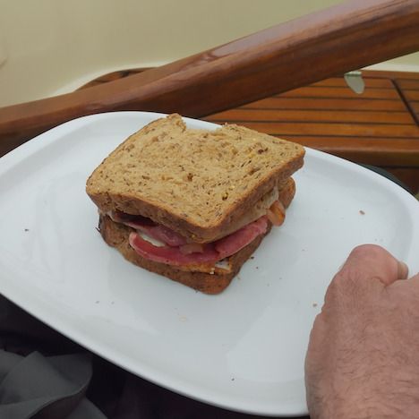
Flask of rum out and served-up in glass tumblers.
Sea-scouts into lock, outer gates closed and lock filled. Into floating dock and found allocated mooring space at pontoon.
(R. Smith, 17Apr2023, 18Apr2023 (more pics))