Practicing for my "Short Range Certificate" - take that as "Marine VHF Radio operator's permit" - which I passed on 08July2022 - I took some famous shipwrecks as the basis for practicing Distress messages.
The one which begged questions was the wrecking of the "Torrey Canyon". I put those thoughts to one side until I passed my Certificate. Then I started asking-around on the premise "The official version of what happened makes no sense...!"
The oil tanker "Torrey Canyon" wrecked on Pollard Rock, part of the
Seven Stones rocks between the Isles of Scilly and Lands End (the
Westerly tip of Cornwall) at 0850 on the 18th of March 1967.
The ship broke up, releasing its cargo of over 100thousand tonnes of
crude oil, causing the first mega marine environmental disaster.
A result of our runaway thirst for fuels.
For all further detail - I delegate to the "Wikipedia" articles SS Torrey Canyon and Torrey Canyon oil spill
Web searches like "torrey canyon investigation report" find official documents of the time.
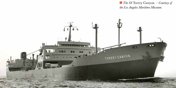
Few pictures found of the ship before the disaster.
Ship before it was lengthened?
[Credit / copyright as displayed]
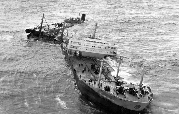
Wrecked on Pollard Rock, broken-up after tide cycles.
[Credit / copyright Safety4sea website]
The ship sailed with a cargo of crude oil from Kuwait (Arabia), around
the Cape of Good Hope and up the West Coast of Africa, passing the
Azores and heading for Milford Haven (South Wales).
But wrecked on rocks off the supposed course a shortish distance
before reaching Milford Haven.
The ship should have passed to the West out-to-the-Atlantic side of
the Isles of Scilly.
But passed East of the Isles of Scilly, in the constricted seaway
between the Isles of Scilly and the Western tip of Cornwall. Where it
struck Pollard Rock, part of the Seven Stones rocks.
This was attributed to "navigational error".
It makes no sense that the ship was off-course.
From the Azores to Cornwall is about 1160 Nautical Miles (2145km), and
to pass 5 miles West of the Isles of Scilly would mean being in a
target position within about +/- 1 mile (you neither want to
run-aground nor increase your voyage length).
In those days before satellite navigation ("GPS", etc.) an autopilot
on a ship could "only" hold a heading (the bearing the ship is
pointing).
[Now / since "GPS", autopilots on ships can hold "course-over-ground"]
Holding heading, effects like wind and currents can make a ship err
"sideways" off the intended chart course.
Given how imperative arriving in accurate position off the Isles of Scilly was, there seems no way the ship's crew over that leg of the voyage and the final night were not using other means to determine their absolute position - radio direction finding including "Loran" , celestial navigation , etc.
My instinct is those measurements were taken but not entered into the ship's log because of what they intended to do...
Finally (!?) - the Bishop Rock lighthouse on the Scillys, being the
Western-most lighthouse in the region, has and had then {???}, a
massive 29 miles visible range. Everything in the report of the
wrecking implies visibility was good (eg seeing the fishing
fleet in the narrow East of Scillys channel; seeing that already among
the Seven Stones rocks). At 17knots, the lighthouse would have been
an hour and 40 minutes steaming away when seen in the darkness of that
March night.
By nothing but trigonometry; at 29 miles distant, being 6 miles to the
side of the intended course-over-ground needs a course correction of
11.7degrees (not a lot) and lengthens the sailed distance by 0.6 of a
mile (small), which would cost 2 minutes and 10 seconds of steaming
(negligible).
That perception is the basis of this article and my investigation.
That thought was parked until I passed my "Marine VHF Radio operator's permit", then my very first phone call got the response... {see next paragraph}
"You've got it - the inquiry findings do not make sense"
Ships heading Northwards from the Bay of Biscay are prohibited from passing East of the Isles of Scilly, by order of the maritime authorities. The risks are too high. That is "public" knowledge.
Regarding passing to the wrong side of the Isles of Scilly - all are due to random navigational errors; none happening when the currents are against the direction the ship is travelling (to a majority approximation). ie these "errors" are not as random as they are claimed to be.
Why do it?
There is a small saving in distance to destination. But additionally, the strong currents in the constricted waters between the Isles of Scilly and Lands End if in the favourable direction can significantly shorten the passage time.
Then in those days before ship position transponders existed there was a high likelihood of "getting away with it" taking a route you shouldn't.
Then if you were noticed ("caught") you had a well-rehearsed speech about navigation error being identified when it was too late to regain the intended course...
So I started to investigate and "piece things together" in-earnest.
When passing the Azores, it was realised that the ship had (only) 3
additional hours beyond the shortest possible estimated time of
arrival (ETA) at Milford Haven to be able to get into Milford Haven.
After which the ship would have to wait for a week before it could
next get into Milford Haven. Which would be an expensive delay.
{is this stated? or is this surmise only? (it's definitely
correct)}
Due to the two-week cycle of the tides, from the large-vertical-range
Spring tides (no relation to the seasons) to the small-vertical-range
Neap tides then back to Springs.
It seems {confirm?} that the large size of the Torrey Canyon meant it
could only get into Milford Haven on the high water of Spring tides.
If the current was Northwards - the same as the ship's overall
direction - at about 0730 {{{?}}} on the morning of 18March1967, then it would
seem that the conjecture of on-purpose "sneaking" inside the Scilly
Isles seemed supported.
If the current were Southwards at the fateful juncture then, contrary
to conjecture, it would appear that this was a genuine navigational
error. With different overall appraisal of the situation.
So I needed to find out what the tide was doing and the resultant currents at 0730 on the 18th of March 1967...
My apparently leisure sailing quest - dinghy sailing; crewing on yachts - serves an ulterior motive. To learn about maritime and nautical matters.
Working in the West Country (of the UK) as a welder had unexpectedly taken me "on the water". All estuary work, let that be said. I'd "deckhanded" on barges and tugboats, supply boats, crew boats, etc - where tidal currents are strong and the water is crowded with marine civil engineering structures.
I'd heard "apprehensive" (understatement) messages over the marine VHF radio and seen heat-hazes from 2000HP of engines at full power unable to overcome the tide while close to fixed structures.
Finding this question when doing my marine VHF radio operator's permit is exactly the nature of the quest.
Topics
To a high probability of being correct, what was really being intended by the ship's Captain and crew back on the 18th March 1967 depends on knowing the tidal streams. The tidal streams being the speed and direction of the currents in the sea driven by the tidal movement of the sea.
These are inset on many charts, as a time series of 13 miniature charts.
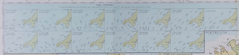
From 1991 Imray chart of Lands End sea region - which is the sea region we are interested in.
The answer to the question is right here in this series of 13 tidal
stream mini-charts.
The challenge now is to know which of these to select.
The significant information on each are the arrows representing
current direction labelled with current speed.
The 13 miniature charts show hourly the tidal streams from -6hrs of
High Water Dover (HWDover) to HWDover through to +6hrs of HWDover.
The answer will come from knowing the HWDover times on 18th March
1967.
Then the correct tidal streams mini-chart can be selected knowing the
time of interest, which is around 0730 when the ship was entering the
area.
Why HWDover?
The tidal streams are a single linked system about Britain, not
uniquely linked to any one place. But with currents which repeat with
the same relative time position in each tide cycle. So High Tide
makes a good reference. High tides being 12hrs and 25 minutes apart.
There can be a single tidal streams atlas if one location reference is
taken; a convenient arbitrary location whose tide times are taken as a
reference. That chosen location being the Port of Dover.
Resulting in those 13 miniature charts which are from -6hrs to +6hrs
of HWDover.
Current strengths vary from Neaps (lower speed) to Springs (higher
speed) and the format of the labels on the tidal stream arrows
provides the necessary information.
This general point about navigation around Britain means that I "only" need to know for 18th March 1967
That said, knowing the local tide times would be reassuring confirmation that all is correct.
This is the crux of the matter.
I intended when starting the search to find local information to the
Land's End to Isles of Scilly sea region and then apply the fairly
invariant tide time difference between here and Dover and Milford
Haven.
The quest revealed to me an abundance of historic tide data - not what
I expected at the outset - so the method to reach the objective
changed.
Website online information is tide *prediction* for next month.
Tide tables are published for a given location for the coming year,
giving the astronomical tide (the tide times and heights given by
celestial alignments).
Finding one for the Isles of Scilly for 1967 seemed infeasible.
Academic research online data sources for the study of oceanography provided the answer.
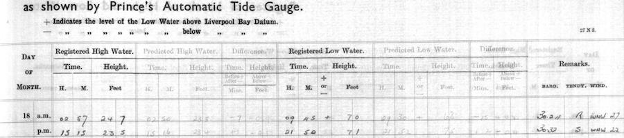
The British Oceanographic Data Centre
provided a "JPEG image" scan of a
hand-written log
of tide times for the Port of Liverpool for 18th March 1967. That
gives what I summarise as "HW-am-predicted 0250".
Taking the
www.tidetimes.org.uk
current tide time difference on 12.07.2022;
Tide Time Difference between St. Mary's and Seacombe (Alfred Dock)
On average over the last two weeks, high tides arrived at St. Mary's
around 342 minutes after they arrived at Seacombe (Alfred Dock), but
this difference varied by as much as 14 minutes either way.
that gives an estimate of high tide at St Mary's of about 0830.
If the tide time difference now (July 2022) is the same as it was in
March 1967. Which it should be a close approximation (?).
However, the size of the tide time difference is concerning large,
assumptions are unchecked, and concern about reliability of the
estimate is reasonable.
The tide ranges at Liverpool are subject to a local very high tide range, so is not easily comparable to other locations. However; the pattern of data (not shown in image for solely 18Mar1967) is that the tides are heading toward a Neap. Significant, and a promising indication to keep investigating.
The British Oceanographic Data Centre also has numeric data on tides (presumably in vast quantities(!)), which it will package as data find results of narrow searches.
My "St Mary's" searches only found patchy data years later than the March 1967. Not useful.
Similar search of numeric data tried on Newlyn from 17March1967 to 19March1967 - success!
The explanation is luck in this case. A nationally important tide
gauge, the historic Newlyn Tide Gauge, diligently recording tide data
for over a century for various crucial applications, is by the seaway
about which I need tide data.
A Web search on "newlyn tide gauge" finds an abundance of information.
Then further good fortune.
The tide time difference between St Mary's on the Isles of Scilly and
Newlyn is only a very few minutes. So it seems there is some simply
relationship of tides across the seaway between Lands End and the
Isles of Scilly. For a tide difference in minutes, the assumption
that tide difference now and tide difference in March 1967 is the
same, if slightly in error, cannot introduce significant errors.
It seems from readings that Newlyn is chosen as a reference for tidal data because it is representative (not an outlier). So I can take the good judgement and experience of others and use the Newlyn data confidently.
Excellent!
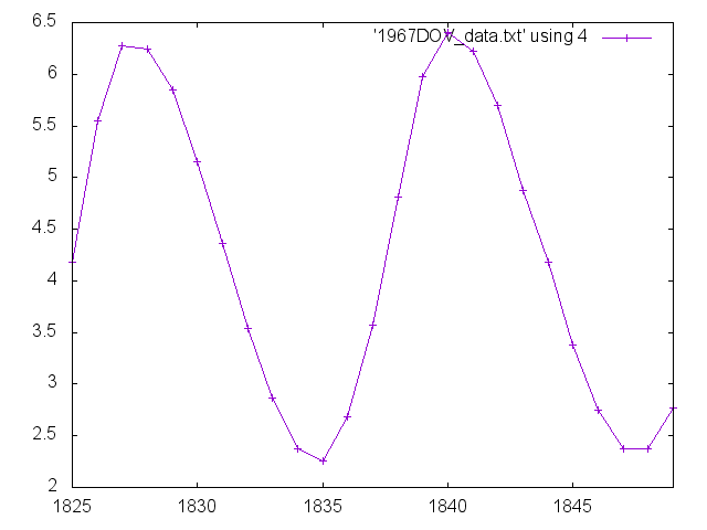
Here is the tide height data for Newlyn between 17March1967 and 19March1967 graphed...
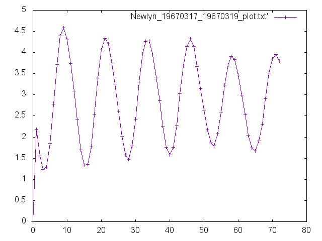
(the numbers along the horizontal axis are data-point numbers and have no other meaning)
High tide on 18March1967 is between point 33 and point 34.
As seen in the raw data.
32) 1967/03/18 07:00:00 3.9680
33) 1967/03/18 08:00:00 4.2640
34) 1967/03/18 09:00:00 4.2700
35) 1967/03/18 10:00:00 3.9380
Meaning 0830 on 18Mar1967
At this juncture in the investigation, applying the commonly held
"tide time difference" that Newlyn high water is at HWDover +6hours, I
confidently established that sea currents would have been Northwards
at the time the Torrey Canyon was East of the Isles of Scilly.
Favouring the passage Northwards up the "forbidden" (to large ships)
East of Isles of Scilly channel.
Proceeding onward, seeking more data in-place and a better more exact
analysis....
Also complete digital data recording to far before 1967.
Dover is the reference port for tidal streams.
Therefore, good reason to go direct to Dover tide data for the HWDover
times.
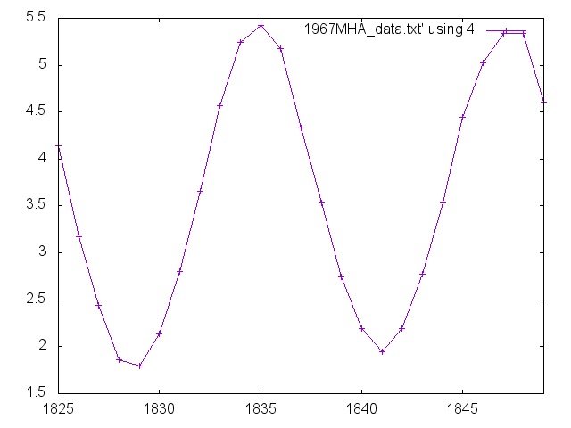
Here it is - tide height Dover for 18March1967, midnight to midnight:
(the numbers along the horizontal axis are the hourly data-point numbers and have no other meaning)
Checked graphically that the data looks valid - it does - then reading the data file directly gets HWDover on 18March1967 at
It is commonly held that the high tide time at Newlyn is +6hours of
HWDover (the high tide time at Dover).
This is seen to be so on 18March1967 - 02:30 + 6hrs = 08:30
Another "excellent!".
Another good data set to well before 1967.
Find HW Milford Haven on 18March1967 as 10:00 and 22:30
This is 1~1/2hours after Newlyn high water.
Reminder - this, Milford Haven, is the destination the Torrey Canyon was aiming for.
Tide height at Milford Haven on 18March1967, midnight to midnight:
The high tide which the Torrey Canyon sought to use to get into
Milford Haven is seen on the right-hand-side of the graph.
This is between datapoints 1847 and 1848 - which will be useful to
note for the next step.
These are the tide heights each hour for the entire month of March 1967:
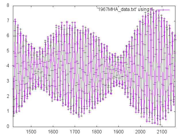
Looking along the horizontal axis beyond datapoint 1848, it is
seen the tidal range is going into a Neap.
This independently supports the assertion in the accident reports for
the wrecking of the Torrey Canyon that the Captain was under pressure
to arrive at Milford Haven by the evening of 18March1967.
At the moment of writing this section, 27 July 2022, I feel
insufficiently equipped to evaluate or comment on the issue of the
vessel Torrey Canyon and navigating into Milford Haven.
Stating an obvious point which is commonly met in navigation. The
high water of a Spring tide will give more depth of water for the
vessel to sail in than the high water of a Neap tide. An important
consideration when making a passage through waters with restrictive
depth and needing to keep a safe margin of water under the keel.
This publication by the Milford Haven Port Authority,
Port of Milford Haven - Entry and Departure Guidelines for Vessels
,
might inform on some of the issues.
Wikipedia has this broader article about
Milford Haven Waterway
,
describing this natural haven and its surrounds.
Inspecting the assertion in the reports of the wrecking that the Torrey Canyon could not have got into Milford Haven for another week if it missed the high tide at 22:30 on the 18th of March, I produce this graph of the tides:
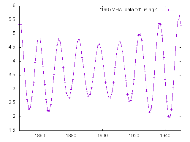
It starts at datapoint 1847 - 22:00 on 18March1967. Then extends far
enough forward in time to see the increasing high tide height
returning from Neap to Spring at least matching the height of the tide on
18March1967.
The 5.36m height of high water of datapoint 1936 matches the 5.33m
tide range on 18March1967.
Datapoint 1936 is for 15:00 on the 22nd of March 1967.
That would mean 4 days of delay getting into Milford Haven.
The next high tide at 5.64m for datapoint 1949 is at 04:00 on 23rd
March 1967.
Which would mean 4~1/2days of delay getting into Milford Haven.
So the assertion in the accident report of "a week delay getting into Milford Haven if did not get in on the high tide at 11pm {{{?}}} on he 18th of March" is not fully supported by this analysis.
(30July2022)
The 7-day potential delay mentioned in the reports if the high tide at
Milford Haven at 22:30 / 23:00 were missed could result from
offloading "slots" and refinery operations, rather than navigational
constraints (not researched whether in reports).
I do recognise that these tidal heights I present are the measured
heights, where the Captain and crew of the vessel would have had
tables of the astronomical prediction of tide range.
Per common nautical knowledge: local "terrestrial" conditions like the
weather, with influences like atmospheric pressure, do affect the
tidal height reached. Lessening it or increasing it. But not
generally by more than a fraction of a metre. Were there a storm
there would be vastly bigger issues than tidal range preventing
passage in and out of Milford Haven...
All these digital data sets - Newlyn, Dover and Milford Haven - concur
in showing the tide range is declining into a Neap. That they concur
is expected.
The 18th of March 1967 was about midway between Spring and Neap. So
about half the tidal range and mid tidal current speed.
So that fits with the Captain of the Torrey Canyon being under
pressure to get to Milford Haven to get into the natural harbour on
the next high tide.
With it being implied but not stated that the Torrey Canyon could not
get into Milford Haven on the high water of a Neap tide.
We earlier saw this image:
We are now able to select exactly which of the 13 tidal stream charts to correctly apply. Given we have
By simple arithmetic, 02:30 + 5 hours = 07:30. So here we are on the threshold of the answer - the correct selection is the HWDover+5hrs tidal stream chart.
Here is that tidal stream chart:
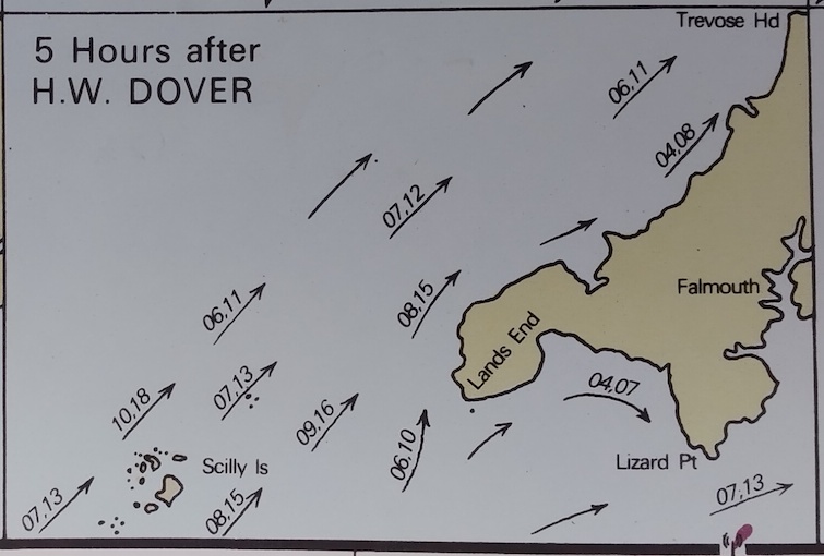
We can inspect that tidal stream chart's tidal stream arrows in the sea region around the Isles of Scilly, labelled as "Scilly Is", and the Seven Stones rocks, which are North-East of the Isles of Scilly, just under the first tidal stream arrow in that direction, which has the label "07,13".
The tidal stream arrows in that area all point broadly to the North-East, directly signifying the currents are to the North-East.
Stating the commonly applied tidal current speed label notation:
Each tidal stream arrow is labelled with the seawater current speed as
a pair of two-digit numbers. These are, multiplied by 10, the Neap
tide speed and Spring tide speed. Thus "14,25" is 1.4kt at the Neap
tide and 2.5kt at Spring tide. Likewise, "04,07" is 0.4kt Neap and
0.7kt Spring.
The tides have been identified for 18March1967 as mid-way between Spring and Neap tide. Therefore, the arithmetic mean ("average") of the two numbers would be the recognised way of getting an estimate of the current speed at that date.
Making a subjective evaluation; for the three tidal stream arrows in the region of the channel just East of the Isles of Scilly, which have
However: local knowledge suggests that the tidal current in the
smallish channel immediately East of the Isles of Scilly and West of
the Seven Stones is significantly faster than the general tidal flow.
Seawater currents in that channel of 2kt to 3kt are suggested when
mid-way between Spring and Neap (or Neap and Spring).
Which would speed the passage of a ship at that time and be tempting to a Captain under intense pressure to speed up a voyage, where only a couple of hours matter.
It would have been rewarding to find a very clear case; but the information, existing and what has been found in this investigation, do not provide that.
Comment based on inside knowledge is
At a much simpler level, I did identify that the tidal currents were
Northwards when the Torrey Canyon was passing East of the Isles of
Scilly.
Which would contribute to the temptation if under intense time
pressure to "slink" East of the Isles of Scilly.
(noting that then ships did not have tracking transponders, so had a
high chance of not even being observed making a prohibited passage)
I contend that the ship, the Torrey Canyon, being East of the Isles of
Scilly is not a plausible navigational error.
This is more of a question than an assertion. Am I assembling the
concepts correctly? I seek to learn by inviting informed comment.
The value of correctly knowing the ship's position during the voyage
between the Azores and the Isles of Scilly lead to the inference that
methods of "fixing" the ship's position would have been applied.
Radio Direction Finding and "Loran" have already been mentioned.
Then; it beggars belief that some junior officer on the long steam on
autopilot from the Azores to the Isles of Scilly would not have
practiced their skills and looked to earn "Brownie Points" by using
celestial navigation tools like a sextant to obtain a further
measurement of the ship's location.
Local comment is that, as the Isles of Scilly are approached, the
Radio Direction Finding (RDF) transmitters "line up" and prevent
getting a radio triangulation of the vessel's position.
However, that still means that for a significant part of the voyage
from the Azores to the Isles of Scilly the absolute position of the
ship can be determined by RDF. Leaving a smaller final part of the
voyage to the Isles of Scilly where only the heading is known.
Then, as previously described, Bishop Rock lighthouse on the South-Western tip of the Isles of Scilly has a massive visible range, rated at 29miles, so any final course correction to closely clear the Isles of Scilly to the West would involve a small course correction and negligible extra steaming time. With that the small adjustment of heading not needing a re-navigation of voyage.
(30July2022)
There has been a Radio Direction Finding beacon at
Round Island lighthouse [Wikipedia]
on Isles of Scilly since 1927.
"Simple" RDF with radio beacon and loop directional receiver is
notoriously (?) limited accuracy - to within a few degrees(?). Then
conventionally there need to be three beacons on very different
bearings to "fix" position (?).
However - when there is an RDF beacon is on / just-by the next
waypoint, that is a uniquely useful situation(?). The compass
gives an accurate heading (to within +/-1degree?) which can be held on
the charted track to the waypoint. The navigation task sailing North
to the Isles of Scilly then becomes to keep the radio beacon straight
over the bow or to some extent to Starboard, but never any degree to
Port.
The radio beacon should be in radio view from at least 100 miles
distant.
(noting this was before satellite navigation (eg "GPS"), which readily provides absolute position)
The Captain of the Torrey Canyon had from 08:30 to seemingly 22:30,
which is 14 hours, to steam 107 miles at 17kt. Which would take 6~1/4
hours. With bit of allowance for manouvring coming up to Milford
Haven, that would be 7 hours.
Apparently leaving another 7 hours to meet the pilot out at sea and to
get lines to the tugboats attached.
So this - possibly ? - contradicts the perception that the Captain of the Torrey Canyon was under unbearable time constraint.
The story I am putting together here is contradictory.
There would have been a more rapid voyage "sneaking" around the channel just East of the Isles of Scilly between the Islands and the Seven Stones. Both in shortening the distance sailed and in getting strong tidal currents assisting the passage.
On the other hand, there appears to have been enough time to get to
Milford Haven passing the "proper" West, "Atlantic", side of the Isles
of Scilly.
Therefore not taking the risks which would cause much apprehension.
Encountering the fishing fleet trawling in the channel - doing as they
do and having every right to do - was a probable event. Which looks
to be an example of the type of excessive risk of the prohibited
"sneaked" route.
Explaining - the trawlers cannot quickly do anything about the nets
they are towing, and a tanker ploughing through the nets would
likely capsize or sink the trawlers.
The Captain of the Torrey Canyon would have known the trawlers were
trawling, both from appearance and activity, and from the "am
trawling" lights and markers displayed.
The tanker would likely be immobilised by the nets, possibly
comprising some steel-rope, wound around the propeller.
The investigation has been a pretext to learn. I am happy it has served its purpose. My effort with the finding of data and producing analyses has earned me informative and engaged conversations with persons of significant nautical background.
The official "findings" in the official reports on the wrecking are certainly twisted by a systematic effort to blame the Master so the ship owners are not liable for clean-up costs to mitigate the huge environmental damage caused.
What came into view in background reading is that bureaucratic inertia
and lack of imagination had left historic rules no longer appropriate
to the vastly bigger ships with their hazardous cargoes.
Previously, good economic order called for minimising loss of ships.
If a ship were lost, the concern was the value of the ship lost and
the loss of the trade it might have had.
The wrecking of the Torrey Canyon had the value of the lost ship
become insignificant and the huge costs of environmental damage
mitigation be the primary concern.
New rules reflected that newly recognised reality. {{{?}}}
Be your own judge of what happened. Mine only an offering to be considered.
I remain somewhat amazed that this campaign of investigation came about as a side-effect of studying for my marine VHF radio operator's permit.
(R. Smith, 13Jul2022 to 14Jul2022, 25Jul2022 to 27Jul2022, 28Jul2022
(lang.eds, date restated), 30Jul2022 (additional info. - in italics))